
Finding Who Lives on Brighton Streets
A street directory search should name what each record proves. The Adams Assessor can identify an assessed owner and a parcel. GIS can show the surrounding polygons, subdivision, boundaries, and map layers. Landmark Web can place an owner, seller, lender, or other party in a recorded document. The voter system can show a registration record when the fields match and the voter is not protected. Historical directories can suggest an earlier occupant. None of these alone is a full household roster, and an assessed owner is not automatically the person living at the situs.
Use the address as the stable starting key. Save the street spelling, direction, number, ZIP, city or county label, and search date. If a portal returns more than one parcel, compare subdivision and legal description before comparing names. A mailing address may be elsewhere. A permit applicant may be a contractor. A voter record may be inactive. Good street work keeps these roles visible.
- Check the Brighton GIS boundary and determine whether the parcel is in Adams County or on the Weld side of the city limits.
- Open the county PropertySearch or Basic Web Map and search the address, owner, parcel, account, or street range.
- Copy the parcel number, subdivision, situs address, owner names, and mailing address into separate columns.
- Use the parcel and legal description to choose a Landmark deed result, then save the reception or instrument number and date.
- Use a lawful voter list or individual lookup for registration evidence, and use a directory, census, or newspaper for a past household.
The street directory is strongest when it shows a reproducible chain: address to parcel, parcel to record number, record number to source image, and source date to interpretation.
Assessor Search by Brighton Address
The Adams County PropertySearch publishes the fields most useful for a Brighton street directory: Owner, Address, Parcel Number, Account Number, County Permit Number, Account Type, and Street Range. The live application is dynamic and returned a 403 during the research inspection, so the exact result screen should be checked at the time of use. The county's assessor maps and data page provides downloadable database files, file layouts, and GIS links as an alternative route.
| Owner | Name search for an assessed owner or organization; test surname and spelling variants. |
|---|---|
| Address | Situs or property address; try directional words, ordinal forms, and partial street names. |
| Parcel Number | Unique parcel key that connects the map result to an assessor report. |
| Account Number | Assessor account identifier, useful when a parcel has multiple record categories. |
| County Permit Number | Permit-linked property search; the permit record is activity evidence. |
| Account Type | Optional category filter; the full live option list was not exposed. |
| Street Range | Optional range filter for browsing a run of addresses. |
Use the assessment result as a current-owner clue, not as proof of occupancy. A property account can carry value, characteristics, exemptions, sketches, and qualified-sale data. Those fields describe assessment work. The county's disclaimer says parcel information is not an official survey, which is why a map boundary should not replace the recorded legal description.
Adams GIS Layers Along a Street
The Adams County GIS Interactive Maps page links Basic and Advanced Web Maps. The official parcel REST layer is searchable, identifiable, queryable, copyable, and snappable. Its useful identity fields include `PARCELNB`, `OWNERNAME`, `OWNERNAME1`, `OWNERNAME2`, `CONCATADDR1`, `CONCATADDR2`, `OWNERADDRESS`, `OWNERCSZ`, and `SUBNAME`. A map click can therefore move a street address into a parcel number and subdivision before the deed search begins.
Layers can add city boundary, subdivision, zoning, land use, permits, districts, and street or addressing context. City GIS also links Adams and Weld property systems. Eye on Adams adds building permits, code violations, and land-use cases for areas covered by its map. Coverage differs between incorporated Brighton and unincorporated Adams, so note the boundary before reading a case as a street fact.
The county parcel map is the visual bridge between a named street and the address records behind it. Use the live map for current geometry and the REST metadata for field names; do not copy a map as if it were a legal survey.
Brighton Records Searchable by Street
Several record sets can be keyed from a street, but each has a different answer. This coverage table is a street directory map of sources, not a claim that one row contains every person at an address.
| Record Set | Key | What It Shows | Access |
|---|---|---|---|
| Adams Assessor | Address, parcel, owner, account | Current assessed owner, situs and mailing fields | PropertySearch, data files, GIS |
| Weld Assessor/GIS | Address or parcel | Parcel evidence for the Weld portion of Brighton | Route from Brighton City GIS |
| Adams parcel REST | Parcel number and map click | Owner names, address fields, subdivision | Public layer with assessment disclaimer |
| Landmark Recorder | Party, legal description, instrument | Deeds, liens, plats, recorded roles over time | Online index, image, counter |
| Brighton permit reports | Address and report date | Permit type, valuation, certificates, subdivision | City reports and records request |
| Eye on Adams | Map, case, address | Unincorporated permits, code, land-use cases | County map, filters, alerts |
| Voter list or lookup | Name plus ZIP or lawful list | Registered name, address, precinct, party, history fields | SOS lookup and list request rules |
| Directory or census | Street, address, year | Past occupants and households at a point in time | Library, archive, FamilySearch, NARA |
The parcel number ties current map work to selected deeds and permits. A historic street guide supplies a different kind of address key. The right sequence depends on whether the question is about a current owner, a recorded transaction, a public activity record, a registered voter, or a past household.
Situs and Mailing Addresses Differ
Brighton street research often fails when the owner mailing address is treated as the physical home. `CONCATADDR1` and `CONCATADDR2` describe the parcel or situs side of the county layer. `OWNERADDRESS` and `OWNERCSZ` describe where the owner receives mail. The owner may have more than one parcel, use an agent, use a post-office box, or have a mailing record that has not caught up with a move. A mailing address is a clue about the account, not proof of where a person lives.
The voter system has its own residential and mailing fields and its own update cycle. USPS verifies delivery geography and ZIP, not ownership or occupancy. A court filing captures an address at a filing moment. A permit captures an applicant or project location. A street directory should show those distinctions rather than flatten them into a single “resident” label.
- Situs address
- The physical address assigned to a parcel by a local addressing or assessment system.
- Parcel
- A mapped land unit identified by a parcel number and legal or subdivision context.
- Plat
- A recorded map that lays out lots, blocks, streets, or subdivisions.
- Criss-cross directory
- A historic address-first directory section that can point to an occupant or telephone entry.
Brighton Permits Add Address Dates
Brighton's Reports page publishes commercial and residential permit reports, permits by subdivision, all permits, certificates of occupancy, solar, Adams and Weld reports, valuations, population, and licenses. Published report patterns can carry record number, permit type, issue date, amount or valuation, and location or address. That gives a street directory a date anchor for building work or a change at a parcel.
Eye on Adams may provide building permits, code violations, land-use cases, filters, and email alerts in unincorporated areas. The city report and county map are not interchangeable. Check whether the address lies inside Brighton municipal limits and which county holds the parcel before comparing results.
A permit or certificate dates an activity at a location. It does not establish that a named applicant occupied the property, and it does not identify every person connected to the site. Use the record to guide the next deed, newspaper, or directory search.
Voter Address Visibility by Street
The Colorado voter lookup is designed for an individual match, using first name, last name, ZIP, and full birthday. A street-wide search cannot be recreated by guessing birthdays. Adams Elections offers public Registration Master List and Voting History List products, and the Secretary of State provides statewide products by request. Ordinary public fields may include name, residential address, party and date, phone if provided, gender if provided, birth year, status, and whether the person voted.
SSN, driver-license number, full birth date, signature, email, protected addresses, and ballot choice are not public fields. The Address Confidentiality Program and the first-responder and spouse restriction under HB25-1195 can remove or restrict an address. A non-match is therefore a protection or eligibility signal as often as it is a search problem.
For a lawful street study, publish the method and source date rather than a raw address list. A Brighton street directory is more accurate when it explains what was searched and what remained outside the record.
Recorded Names Along a Brighton Street
Landmark can follow selected names from a current parcel into a chain of recorded documents. Search the owner as a grantee around the acquisition date. Save the grantor, grantee, document type, recording date, reception or instrument number, book or page when shown, and legal description. Then search the seller as an earlier grantee and constrain the result by lot, block, subdivision, or other legal description. The recorder's index is party based, so address alone will not guarantee a complete chain.
Adams County's historic books date from 1902. The current online earliest year is not confirmed, while the 2019 budget's 1915-current description is an older online coverage clue. The Historic Alpha Index has Book Indexes, Scan Only, Criteria, Final Verified, and page controls. If an early street address is missing, ask Recording about the counter books or use a plat from the State Archives finding aid for 1905-1941.
Use the Adams recorded-document portal for a live search. A recorded party is not automatically a current resident, and a deed sequence is not continuous occupancy proof.
The Adams official parcel REST layer supplies the field schema behind a map-based street search.
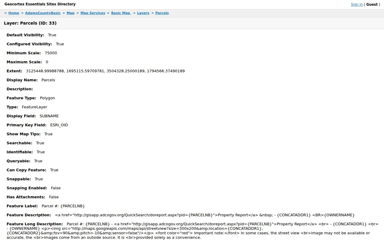
The parcel layer image shows why owner, address, subdivision, and parcel fields belong together before a name is carried into the deed index.
Main, Bridge, and 4th Address Clues
Brighton's central record vocabulary repeats around Bridge Street, Main Street, and 4th Avenue. City documents identify Bridge Street as State Highway 7 and 4th Avenue as State Highway 2, while US 85 and I-76 signal work involves CDOT. The old courthouse at 4th and Bridge became City Hall, and historic resource addresses include the Great Western Sugar Factory at 701 N. Main and Brighton Depot at 269 Bridge.
Historic plans normalize forms such as “5 S 1ST AVE” to “5 S FIRST AVE.” No official citywide renumbering or renaming year was located. Search both forms, keep the old spelling in the research log, and use the legal description or plat to decide whether two results refer to the same place. Do not insert an invented crosswalk year into a street directory.
What the Street Directory Cannot Show
Public address records do not list every person at a parcel. Renters, household members, utility customers, delivery records, unregistered occupants, and many protected residents are outside the ordinary parcel result. DMV address information is controlled. Vital and adoption records are confidential. Juvenile, sealed, and expunged court material can be restricted. Neighborhood adjacency also proves geography, not a personal relationship.
Use records for family history, reconnecting, civic research, property history, or personal safety awareness. Keep a source date, verify important facts with the custodian, and do not use a street or address trail to follow, threaten, repeatedly contact, or intimidate a person. If the goal shifts from a whole street to one person, the Brighton resident lookup workflow keeps the identity checks in the right order.
Lawful use. Brighton address records are for personal, lawful research. A parcel owner, recorded party, voter, permit applicant, or historic occupant is not a license to intrude on a private person, and misuse can violate Colorado law.